Whether you're short on time or short on cash, you can see some of South Island's best scenery by taking you and your shoes on these awesome days hikes.
Nothing is cheap in New Zealand, and trekking is no exception. If you want to do one of the "Great Walks," you can expect to pay $54 a person to sleep in a bunk bed in a room with 50+ other people. That's just not my style.
So instead of spending the money there, explore New Zealand's South Island on these super scenic day hikes--ranging from just a few hours to a whole long and tiring day.
Then when you're back in your hotel room, take a hot shower and toast with a well-earned beer. After all, you deserve it.
Five Best Day Hikes on the South Island, From Shortest To Longest
Hooker Valley Track, Mt. Cook National Park - 3 hours
If you're only going to do one hike in New Zealand, make it the Hooker Valley Track in Mt. Cook National Park. (Also, ask yourself why you're in New Zealand.)
Just the drive into Mt. Cook National Parkis unreal, as you basically have another crazy blue lake to your right and snowcapped mountains ahead of you. However, instead of stopping to take in the views, we suggest pushing on to the parking lot and hitting the trail. Clouds roll in early afternoon, so you want to get the hike in as early as possible.
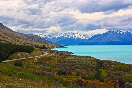
This 10km hike is much easier than the one to Key Summit and the clear weather made it about 1000 times more spectacular. You cross a few swingbridges and gaze at glaciers tumbling down mountains before rounding the bend and seeing the whole of Mt. Cook right in front of you—seemingly.

From then on, your hike pretty much consists of gawking at Cook and the glaciers. The one thing I didn't expect was for the end to be so spectacular.

Save your sandwich for the beach, Hooker Glacier, and icebergs that seem to magically suspend on the water's surface.
Rob Roy Glacier Hike, Mt. Aspiring National Park - 3 hours
The Rob Roy Glacier Hike is supposed to compete with the Hooker Valley Track in terms of views, but getting there is much more difficult. The hike takes place in Mt. Aspiring National Park and is about 1.5 hours outside of Wanaka. Not only is the road unpaved for 30km, but sometimes you have to ford rivers.
Yes, you read that correctly. And this is from the girl who never won Oregon Trail. (Rob would like everyone to know that he ALWAYS won and doesn't know how he married someone who always picked the banker as her occupation.)
Saying the scenery was superb doesn't do it justice. The entirety of the drive is through a valley and on each side of you are cliffs dotted by waterfalls. Going 20km/hour gave us plenty of time to enjoy the views, but the going was just getting tougher. The first few fords were okay, but around the fifth one we decided we were too nervous to push the car farther. So we parked it and got to walking.
TIP: Planning to drive to the Rob Roy Glacier Hike? Opt for a 4WD and prepare to ford rivers—despite what your hotel tells you
The scenery on the hike itself is somewhere between Key Summit and Hooker Valley in terms of terrain and challenge. It was a bit cloudy, so the views up top weren't as spectacular as they could have been. Still, seeing the Rob Roy Glacier tumbling down a mountain was impressive.
Unfortunately eating underneath a glacier is cold, so we stuffed our sandwiches into our face and quickly descended back into the land of sun, wildflowers, and sheep. Corny? Yes. True? Absolutely.
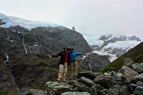
Worth it? It would have been better had we been able to see the peak of Mt. Aspiring and the range, but the whole experience (including the hitchhiking after we left our car) made the hike a win.
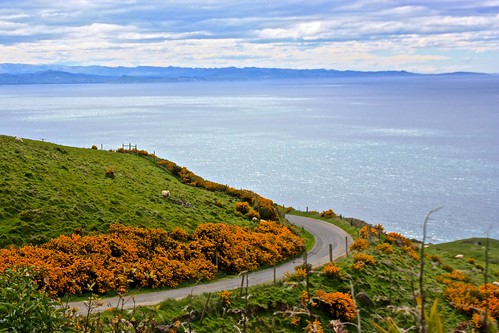
Otago Peninsula Walks - 4-6 hours
Exploring the Otago Peninsula requires a car because these walks aren't connected. But doing these walks in a day is a great way to explore the many hidden spots on offer!
Start your day by taking the coastal road from Dunedin all the way to the albatross center for a chance to see the birds for free. Even if you don't spot them, you'll have great views of the water and coast, which I find more fascinating than giant birds. (Bring binoculars or a good zoom lens.)
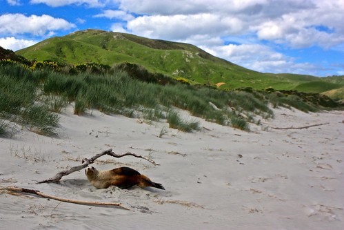
On the way back, veer inland to take in Allan's Beach. You may spot penguins here, but if you don't, you'll definitely see sea lions. The drive to the beach is worth doing even if you have no interest in the beach itself.
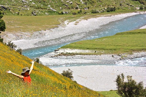
Do the hike to Lover's Leap. Amazing views, lots of sheep.

Head to Sandfly Bay to spot the yellow-eyed penguins. Arriving around 6pm will give you the best chance to see them come out of the water, but we lucked out around 8:30 and watched two little guys struggle up the hill for an hour. If the weather holds, you'll get an amazing sunset here. If it doesn't, you'll always have the sea lions for company.

Ben Lomond Summit via the Skyline Gondola Viewpoint, Queenstown - 4-7 hours
For spectacular views of Queenstown, the Remarkables, and Lake Wakatipu, you can't do much better than Ben Lomond Summit.

One of the best things about this walk is that you can access it right from Queenstown. You have several options, including paying to take the Gondola up, which cuts about 1 hour of walking. You can also take the Tiki Trail (not recommended as it's better to take down) or the Skyline Gondola Access Road. The latter is a wide open road and the fastest way to access the trail to Ben Lomond.
The problem with hikes that go to mountain tops is that your eyes are peeled to the trail as you hike up and as you hike down. Until you're at Ben Lomond Saddle, this isn't really a problem since there's not much to see. Once you're there, about 1.5-2.5 hours into your hike depending on speed, make sure you take a breather and look around.
Take some jumping shots if you're so inclined!

The Summit is a further 1 hour beyond the Saddle, and that's where the views really open up. There was snow on the ground when we hiked, which also meant ice. If you're doing this hike in spring or fall, you may encounter the same, so make sure you watch your step.

If you get an early enough start from Queenstown, you'll be one of the first ones at the top. It took us 2.5 hours from our apartment in town and we left at 8am.

You can go down the way you came up (should take about 1.5-2 hours), or better yet, detour to the Gondola.
Check out the views over Queenstown from here and then take the Tiki Trail down, which will take you under ziplining platforms and past all sorts of funky carved wood chairs.
The Tiki Trail drops you off right in town, so you can grab drinks immediately after!
Another option, and the one we took, is to follow the Moonlight Track from the Saddle to Arthur's Point. Note that while the sign says 3 hours, it's wrong. DOC typically overestimates times, but this time, either someone ran or someone just screwed up.

Allow at least 2 hours from the Saddle to reach the Moonlight Track, which includes jumping the fence as soon as you come to it. Do not follow the fence up. It goes nowhere. From there, it's another 8km or so until Arthur's Point. The last hour of the walk is quite pretty, as you can see the Shotover Canyon with the swing and jet boats. But adding this route makes it a very very long day.

Hitch a ride home if you do end up taking this side trip and allow at least 8 hours for a fast walker.
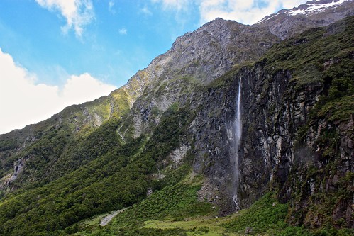
Routeburn Track from Routeburn Shelter to Harris Saddle and back - 7-10 hours
Don't listen to the people who tell you doing this in one day is crazy. In fact, compared to some of our other hikes, it was downright easy.

The day walk allows you to see the best of the Routeburn without paying a penny and the early start/late finish also means you have the track to yourself for much of the time.

Both of those things were wins for us so we decided to give it a go. If you're hesitant about spending money on a Great Walk, but want to see the best bits anyway, this route is a must do.
The drive to the Routeburn Shelter from Queenstown takes about 80 minutes and can be done in any car. It's a stunning route that takes you through some of New Zealand's best scenery. Unfortunately, if you're hiking at a time of year that only has 9 or 10 hours of sunlight, you don't have a ton of time to take the scenery in. Save it for the way back.

Once you're at Routeburn Shelter, the route meanders up and down to Routeburn Flats Hut for 6.5 kilometers, which is the halfway point to Harris Saddle.
You follow the river and see some mountain views, but it's nothing spectacular. This part of the walk took us 1 hour and 20 minutes. If you're going at a more normal pace, it should take 2 hours. Again, this is the halfway point to the Saddle when it comes to distance.
From Routeburn Flats Hut, take a left and start the slow 2 kilometer slog up the mountain to the Routeburn Falls. There are some nice views during this stretch and if you're used to hills, you can make it in about 45 minutes. If you walk slower, it'll take about 1 hour and 30 minutes.

Take a break at Routeburn Falls. Have a snack, take goofy photos, whatever. You only have 4.5 kilometers remaining!

The last bit of the walk is where the views really open up. You have amazing alpine scenery in all directions and the terrain isn't actually that challenging.

We had to deal with a bit of snow and ice because of the frost from the night before (we did the hike in early May), but if it's warmer out, this section seems like it would be fairly easy and enjoyable.

At the top of the Harris Saddle, there's a hut for you to eat lunch in case it's cold outside. Unfortunately for us, the beautiful weather down below did not make it up to the Saddle, so we were met by a lot of clouds.
Once you eat and snap photos, just turn around and return the way you came.

It's 27 kilometers total. It took us 6.5 hours of walking with 1 hour total for breaks, so 7.5 hours in all. Allow 10 hours if you aren't used to trekking long distances, but don't let anyone stop you from trying this spectacular track!

What Are Your Favorite Day Hikes on the South Island?
Do you have any other suggestions to share with our readers? Let us know in the comments!
Comments